The Parish of Mavesyn Ridware
Mavesyn Ridware Parish has historically been arranged into four areas for the purposes of church and census returns. These are Mavesyn proper, Hill Ridware, Rake End and Blithbury.
Mavesyn Ridware
Mavesyn Ridware itself has startling evidence of early settlement in the form of a Neolithic causewayed enclosure, located in the large flat fields beside the Trent, south-east of the church. A large central area is surrounded by three concentric ditches, excavated to form banks or ramparts which must have been impressive in their day. The monument is now invisible on the ground, but aerial photographs reveal its extent. The enclosing banks are interrupted at intervals by entrances, or causeways.
These enclosures were first built between 3000 and 2500 BC, about 500 years after farming began. Probably serving as tribal centres, they would have fulfilled a number of functions. It is believed that the corpses of the tribe were exposed within the enclosures to the weather and scavenging birds, until the cleaned bones were interred communally in long barrows. There is also evidence that the enclosures were used defensively as forts, as some show signs of burning or attacks by archers. They may also have served as marketplaces and as enclosures for livestock. A possible parallel is with the nomadic Indians of the Western United States who did not have permanent settlements, but who gathered at the same place at certain times of the year for trading, matchmaking and rituals like the Sundance.
Further evidence that this was an important tribal ritual centre is a cursus, extending north east from the enclosure in the direction of Hill Ridware. This type of monument, consisting of two parallel ditches, is even more mysterious than the causewayed enclosure, but it may have been a ceremonial or processional way. Two Bronze Age round barrows are located near the causewayed enclosure and show that this area of the Trent continued to be an important ritual site for a long time.
The Mavesyn Ridware causewayed enclosure is significant because it is one of the most northern examples of this type of monument. There is another located near Alrewas, but the majority are found in the chalk downlands of Oxfordshire, Wiltshire, Dorset and Hampshire. The reasons for this are unknown. It may be that population densities were much greater in the south at this time as the light chalk soil was easier to plough than the dense Midland clay.
The first documentary evidence of settlement is in the Domesday Book. It tells us that ‘Rhydware’ belonged to the Saxon Earl, Algar. William I presented the estate to one of his followers named Roger de Montgomery, and Ascelin a Saxon was permitted to hold it under him. The name ‘Mavesyn’ is derived from the name and family of Malvoisin, a French knight who came by the manor following the Conquest. The name reputedly means dangerous neighbour, being French for a siege tower that was constructed to attack castles in the Dark Ages. There is no clear evidence as to how Malvoisin acquired the manor, but it seems likely that it was granted for services at the Conquest. The first reliable reference is to Hugo Mauvoisin who lived in this lordship and was frequently styled Hugo de Rideware. He founded the priory of Blitheburgh (now Blithbury), between 1130 and 1160. The family continued as lords of the manor through the generations until Sir Robert Mavesyn was killed at the Battle of Shrewsbury in 1403. He had two daughters, Elizabeth and Margaret. Elizabeth married Sir John Cawarden in 1418 and their son John succeeded them at Mavesyn Ridware. (Margaret married into the Handsacre family, thus ending the feud that had resulted in the death of her future father-in-law.) The manor remained in the hands of the Cawardens until 1611 when John Chadwick became lord of Mavesyn Ridware through his marriage to Joyce Cawarden. The Chadwicks retained the manor until John de Heley Mavesyn Chadwick became bankrupt in 1883 due to gaming debts. According to Mark Eades, ‘It took 800 years to accumulate a fine estate in Staffordshire, Warwickshire, Derbyshire and Lancashire and one profligate generation to lose the lot!’
The Manor House and Gatehouse
The Mavesyns moved from their manor house at Blithbury, on the site of the present Blithbury Bank Farm, to Trentside around 1140 when they founded the Church. According to Mark Eades (The Old Hall, A Historical Description and a Guide to the Gatehouse):
‘It is logical to presume that at that time they built a Manor House adjacent to the Church on the site of the present Hall. The nature of the original house is entirely conjectural. It would certainly have consisted of a Hall with outbuildings and was probably enclosed within a moat.
The Manor House appears to have developed into a quadrangular complex. The final building of this evolutionary development was probably the Gatehouse, which completed the quadrangle by enclosing the north side of the courtyard. The Gatehouse is all that remains of the medieval Manor House.
The Gatehouse is a timber framed building of two storeys with a massive Crown Post Roof. The timbers for the frame were felled in late 1391 or before the spring of 1392. In 1995 the Nottingham University tree-ring dating laboratory took eight core samples from various timbers and were able to establish this date accurately. In the Middle Ages oak timbers were worked unseasoned and therefore the building date is 1391 or 1392. The first record of the Gatehouse itself comes in 1407 when Bishop John Brughill granted Dame Johanna Malvesin a license to have masses celebrated in the family oratory, which tradition places in one of the main chambers of the Gatehouse.’ Mavesyn Ridware was designated a conservation area in 1974. The documentation relating to this states that ‘the Gatehouse is one of the architectural show-pieces of Staffordshire’. The neighbouring Old Hall on the site of the Manor House dates from 1718; the attention to detail and the proportions give it a far nobler appearance than the late 18th century description, “a convenient box”, would suggest. Nearby are the fishponds as a further reminder of the Middle Ages.


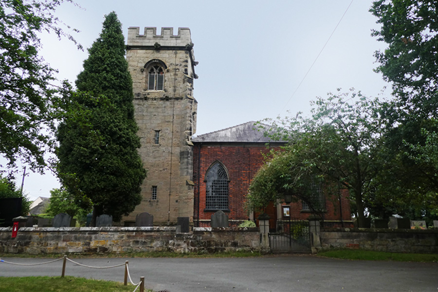
The Church of St Nicholas
The Church of St Nicholas was founded in 1140 and, as noted in the church guide:
‘the tower and north aisle are thought to date from this period. All except the tower and north aisle were rebuilt to be as it appears today. This rebuilding was undertaken in 1782, because the whole church except the tower and Trinity Aisle being very damp and ruinous was taken down, by a faculty and a new one erected in the same year at a cost of £730’. The Trinity Aisle may once have been a family chantry chapel and contains many effigies and tombs of the lords of the manor since the 12th century. Of particular note is the tomb of Hugo Mavesyn, founder of the church and of Blithbury Priory, dated to the late 1100s and forming an integral part of the north wall. The tomb of Sir Henry Mavesyn, the crusader, is also in this aisle.
Sir Robert Mavesyn is buried in a tomb in the Chapel. A translation of the Latin inscription states, ‘Here lies Robert Mavesyn, who was slain at Shrewsbury 1403, standing with the King and fighting by his side even unto death. On whose soul may God have mercy.’
Until the early part of the twentieth century, the church was plastered and whitewashed. For reasons that are not known, the walls were stripped to leave them as they are today. Electricity was brought to the church in 1937.

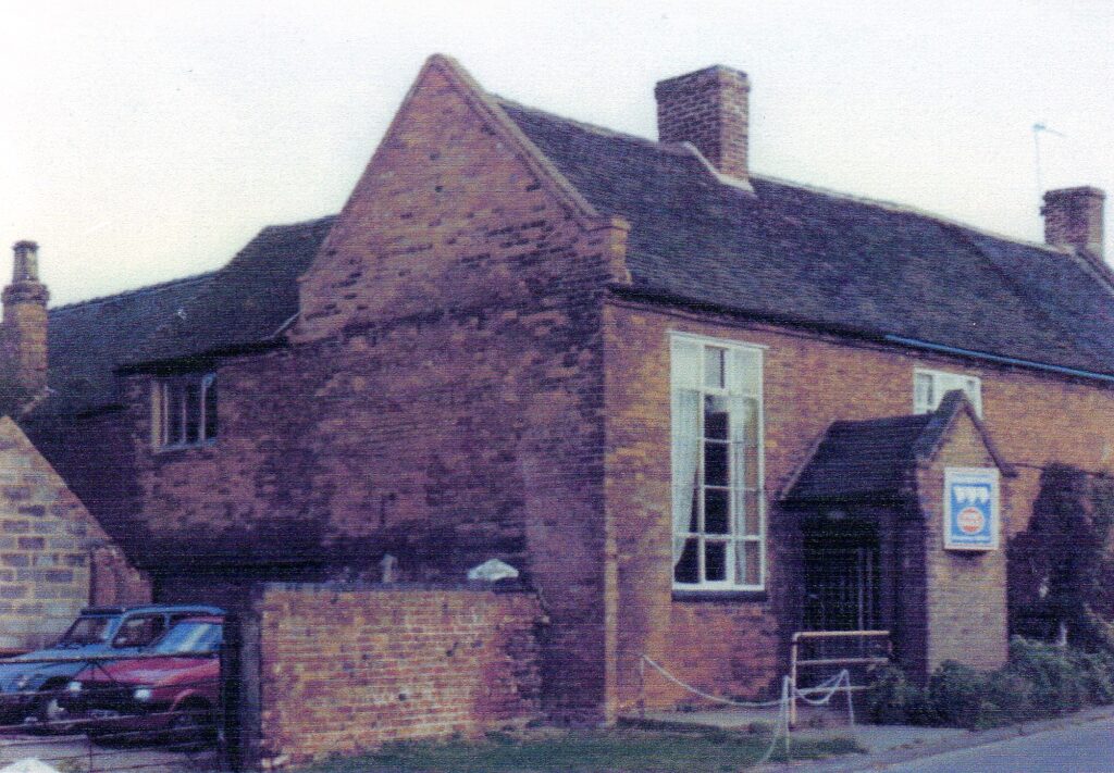
The Old Rectory It is thought that a Rectory was built at about the same time as the church in 1170. Land in Mavesyn Ridware was granted by Hugo Mavesyn senior, to his son Hugo, a clerk, who became the first incumbent. Of the first building nothing remains, apart from two walls in the dining room which are made of large sandstone blocks, similar to those used in the oldest part of the church. A probate inventory of 1672 mentions parlours, a stone chamber and a hall. The Rev John Shaw’s probate inventory of 1710 mentions a much larger building including at least eight rooms, a kitchen, a garret and two cellars (one for beer and one for wine). In 1857 the Bishop commissioned a report on the property, from which the following is extracted:
‘I have made a survey of the Rectory House at Mavesyn Ridware and find it a two storey brick and tile building occupied by a labourer and built in a low damp situation. The rooms are exceedingly low and inconvenient and although in a tolerably good state of repair for so old a house it is wholly unfit for the residence of the Rector; the outbuildings are very poor with the exception of the Glebe barn which has been re-tiled a few years back with good tiles and is in a tolerably good state of repair.
Samuel Guiders, Surveyor. 14th February, 1857’.
The Old Rectory was leased in 1904 to Miss Harvey of Abbots Bromley who ran a private school in the building with her sister until 1914, when the school closed owing to the death of one of the sisters.
The Battle Beside the Trent
An incident of great interest took place in the parish in 1403. Disputes had arisen over the years between the Mavesyns and the Handsacres, whose lands were divided by the natural boundary of the Trent. The following description of the affray is based on the account given in Dent and Hills, Historic Staffordshire:
‘As early as 1382 Robert Mavesyn had leased to John Hammond, fisherman, his fishery in the Trent at Bryggewater, between Handsacre and the Oxonholme Pool, and the miller, one Robert Mulner, got into dispute as to the boundary of the two parishes at the mill dam and floodgates. The dispute resulted in a feud and an affray, ending in a riot, in which the mill was burnt and Lawrence de Frodesley, of the Handsacre party was killed by the Mavesyns.’
This local disagreement was heightened by the political situation of the time when King Henry IV was defending his crown against Henry Hotspur and his father, Henry Percy, the Earl of Northumberland. Both parties were calling supporters to arms: the King at Burton and Percy at Shrewsbury where he was to join forces with Owen Glendower, the Prince of Wales. Mavesyn supported the King, while Handsacre supported Hotspur. Such was the state of affairs when Mavesyn and Handsacre assembled their little bands of tenantry , bowmen, billmen and horsemen, according to their degree. The muster was a hasty one. Mavesyn’s object was to reach the King at Burton, or join him on his march; Handsacre’s to meet Percy’s forces coming from the north…the fight took place… The result was that Sir William Handsacre was killed. A few days after this skirmish Sir Robert Mavesyn was killed at the Battle of Shrewsbury.’
The next generation however seemed to make their peace as Sir Robert’s daughter Margaret married William, the son and heir of the Handsacre knight. The tomb of Margaret Woodford, the grand-daughter of Sir Robert Mavesyn and Sir William Handsacre is in the Chapel of the church. The fight traditionally took place in a meadow just above High Bridge, in fact the actual spot used to be pointed out, and was hard by two very ancient oak trees, popularly known as Gog and Magog. The sketch shows their massive appearance as late as 1896, but by 1920 they were blackened hulls and they finally disappeared in 1921 when they were broken up and carried away during the long coal strike of that year. In 1995, Tom Adams was metal detecting in soil that had been disturbed when gas pipes were being laid to bring gas into the village. He found two coins, a few inches below the ground, in Church Lane that he took to Birmingham Museum to be dated. One was a silver penny of the Archbishop of York’s mint and is thus dated between 1413 and 1422. The other is a contemporary forgery of a copper halfpenny of George III, dated 1775.
Stebbing Shaw’s Account of Mavesyn Ridware
Writing in the late 1790s, Shaw states that:
‘the face of the country is pleasingly variegated, rich and well cultivated, exhibiting an agreeable mixture of corn and grass, the fields being well fenced with flourishing thorn-hedges, luxuriant in bloom, and sufficiently thickened with forest trees’.
He examined the Church Registers that had to be kept from 1538 and required that all ‘christenings, weddings and buryings’ be registered. From this, he collated the following:
| Marriages | Christenings | Burials | |
| 1538-1547 | 20 | 59 | 55 |
| 1548-1557 | 19 | 58 | 52 |
| 1590-1599 | 19 | 79 | 54 |
| 1627-1636 | 19 | 65 | 56 |
| 1690-1699 | 15 | 105 | 60 |
| 1738-1747 | 56 | 128 | 80 |
| 1787-1796 | 30 | 122 | 79 |
Stebbing Shaw also noted some extracts from the Church Book dated 1643 – 1695. The following indicate how the parish of Mavesyn Ridware was caught up in the Civil War of 1642-6. (The original spellings are kept.)
| £ | s | d | ||
| 15th May 1642 | Paid to collenell Bagot towards the maintenance of his majesties garrison at Lichfield in money and returns | 7 | 10 | 0 |
| 20th Jul 1642 | Paid for a mare, sadell and bridle that went to capt. Trevor for his majesties service | 2 | 0 | |
| 12th Sep 1642 | Paid to collenell Bagot towards the maintenance of his majesties garrison at Lichfield in money and returns | 6 | 4 | 0 |
| 29th Dec 1643 | Spent at Mary Edwardes amongst our neighbors and colonel Cromwill soldiers | 2 | 0 | |
| 1643 | Assessment to pay for five horses that were lost (i.e. taken away by col. Cromwill’s forces | 4 | 5 | 6 |
| 17th Mar 1644 | Provisions went to Lichfield for Prince Rupert | 4 | 5 | 6 |
| 1st Apr 1644 | Five men pressed for his majesties service at Dudley castle and sent to Rushall Hall | ? | ? | ? |
| 30th Jun – 2nd Jul 1644 | Twelve teams and 13 workmen to the raising of bulwarks at Lichfield | 2 | 17 | 8 |
| 4th Sep 1644 | To 35 workmen that went to Lichfield towards the raising of bulwarks | 1 | 3 | 4 |
| 27th Aug 1647 | Paid to 20 soldiers that came from Uttoxeter from the seege | 10 | 0 | |
| 28th Aug 1647 | Quatering 400 Scotes, prisoners and 20 soldiers with horses, their guard | 4 | 19 | 8 |
Shaw also noted the following, which gives an indication of the population of the parish over the years:
‘In 25 Henry VIII. Here were 36 householders belonging to this church’ (This is a regnal year, between 22nd April 1533 and 21st April 1534.)
‘And in 32 Elizabeth here were nine freeholders who paid 56s viii d. to the subsidy and Thomas Cawarden was rated for 4s. in land.’ (This would be between 17th November 1589 and 16th November 1590.)
‘At the time the hearth money was collected in 1662, here were 88 hearths which paid 81. 16s. The sum of 6s. 8d. is given annually to the poor by the minister and overseers on St Thomas’s Day. It is paid from a piece called Sandyford, in Pipe Ridware, formerly settled for that purpose by Richard Lyon of Pipe Ridware’.
Mavesyn Ridware Enclosures
The next comprehensive survey of the area following Domesday was undertaken in the 1830s when the Inclosures Act was being finalised. John Myatt (Mavesyn Ridware Field Names, 1992) has extrapolated the following information for agriculture in the parish between these two dates.
‘From the Domesday survey (that states four ploughs) and using the customary ratio of one plough per 120 acres we arrive at an arable area of 480 acres under cultivation around 1066. This would have been in the north and south of the parish.’
From this he deduced that about 1,450 acres remained uncultivated and states:
‘Domesday provides clear evidence of the nature of this middle ground: woodland one and a half leagues long and as much broad. The league was a somewhat variable measure, but if we take it to represent a mile, then one and a half leagues square would represent 1,440 acres – the area of the parish not accounted for by the two manors.
It follows that, during the seven and a half centuries which elapsed between the Domesday Survey and the survey of 1832, this vast area was reclaimed from woodland for farming use. In 1832 only 43 acres of ‘plantations and coverts’ remained and even these appear to have been recently planted, perhaps to provide alternative hunting and shooting opportunities following the enclosure of Needwood Forest.’
In the same publication the probable location of the medieval open fields evident from Tithe maps of 1844 and 1848 have been identified.
‘Three meadows alongside the River Trent were still partially divided into numbered strips on these maps as were parts of two arable fields south east of Hill Ridware.’
They would have been worked from dwellings within the villages. Some of the older existing cottages may have originally been farmhouses with rights in the open field system. Following enclosure, the old farmhouses would then have been let to farm workers or craftsmen who supplied services to the community. Juxta House in Hill Ridware is a case in point. It is thought to be of 16th century or earlier origin and would have been the home of a moderately affluent yeoman farmer. It was also noted that:
‘There is no record of any Inclosure Award affecting the Parish of Mavesyn Ridware and it is assumed that the enclosures were achieved by voluntary agreement.’
Population of Mavesyn Ridware
Census returns show that for 1801 there was a population of 486 in the Parish of Mavesyn Ridware; in 1831 there were 576 people; and this had fallen to 523 in 1841. Forty years after Stebbings Shaw’s survey, White’s (trade) Directory of Staffordshire (1834) lists the occupations of the following inhabitants:
‘Farmers: George Booth, Walter Cope, Edward Matthews, William Saunders, Job Saunders, Christopher Sanders, and Jas Webb at Hill Ridware; Isaac Bevons, Thomas Bolton, W Goodwin, Thomas Rowley, Edward Strongitharm and Elizabeth Moxon in Blithbury; Bartholomew Gough at Cawarden Springs; John Handy, Thomas Jackson and William Taylor at Mavesyn Ridware.’
In Hill Ridware, Hugo Malvesyin Esq lived at the Upper House and the following tradesmen are listed:
‘Thomas Beck, shoemaker; Job Benton, joiner; Ann Brindley, shopkeeper; Richard Brindley, blacksmith; Thomas Bromsgrove, butcher and victualler at the Talbot, Upper House; Thomas Chamberlain, wheelwright; Edward Cope, victualler and shopkeeper at the Royal Oak; James Felkin, tailor; William Handy, blacksmith and beer house proprietor; Edward Longhurst, school master; Rev Marmaduke Matthews; Edward Newman, shopkeeper; Thomas Ordish, shoemaker; Richard Peters, rope and net maker; and Thomas Smith, maltster.’
From the tithe map plots of the same time, we know that Job Benton lived in what is now Briar Cottage and that Thomas Smith was his neighbour in what is now The Maltings in Rake End. Samuel Robinson is listed as a wheelwright living at Cawarden Springs. Sampson Robinson is listed as plumber, glazier and victualler at the Swan in Blithbury and John Haywood as the victualler at the Bull’s Head.
White’s Directory of 1851 states:
‘The old manor house, with a large estate and fishery of the Trent, have belonged to the Chadwick family since the year 1615, and are now possessed by H M Chadwick Esq who formerly resided at Hill Ridware, in a modern brick mansion, called the Upper House, seated on an eminence one mile north of the church and now occupied by Captain Pearson. Hill Ridware Cottage is the pleasant seat of W Harwood Esq.’
The evidence in these directories indicate that the Royal Oak in Hill Ridware seems to have been in continuous use from 1818, the earliest trade directory available. The earliest landlord listed was T Chapman but it later came into the possession of the Cope family.
The Talbot is recorded in both 1818 and 1834 under the name of Thomas Bromsgrove, but there is no mention in later directories.
The Chadwick Arms first appears in the Trade Directory of 1854 under the landlordship of S. Miles. The mystery is: why isn’t it listed before 1854, as the building dates from 1686? A beer house is recorded in the Directory of 1834 under the name of William Handy. Could the Chadwick Arms have been the Talbot, re-named in honour of the local land-owning family? The hunting dog is a prominent feature of its sign. Or, is it the successor to William Handy’s beer house?
Hill Ridware
According to Stebbing Shaw:
‘The most publick road in the parish lay through this village, the stocks and whipping post still stand here, where the three roads meet; and here, I have no doubt, stood a cross anciently, for ‘Le Hyll cross’ is named in 1530.
There are 30 houses and 33 families giving 143 inhabitants. Of the families, there are two farmers, one gardener, one shopkeeper, one butcher, four tailors, three shoemakers, one blacksmith, eleven labourers and two paupers, besides two individual paupers. Here are two publick houses, at each of which an amicable society (instituted in 1772 and 1787) has its annual feast on Whitsun Monday and 29 May.
Though the parish has not the advantage of a resident clergyman, here are two day schools for girls and another for boys, instructed by the parish clerk.’
Rake End
Rake End, according to Stebbing Shaw, was separate from Hill Ridware many centuries back, but when he wrote they were almost joining.
‘Le Rake is named in 1334 and Rakeynd in 1523. In 1334 Robert Mauveysin, and Margaret his wife, granted a cottage, with a curtilage adjoining, and a small piece of land adjoining, where a certain forge used to stand which Simon the smith formerly held in Le Rake, to be held by the payment of three shillings annually and one new head for a broad barbed arrow. The word Rake signifies a road – meaning the end of the village rake or road.Wade Lane House, an ancient stone building, belonging to Mr Chadwick, but occupied by Mr George Webb, a principal freeholder, stands a little retired from the publick road, with which it is connected by a lane named Wade-lane, probably from its being occasionally so watery as hardly to be passed dry shod, the whole village being annoyed by well-springs near the surface. Wadelone is named in 1393, when Agnes de Hanley &c. are presented, at Mavesyn Ridware court, for having blocked up a certain road at Wade-lone by not cleaning a certain ditch. The Well-House is a neat modern brick house, standing by the roadside, erected about 70 years ago, having been lately improved by the present owner, Mr C B Robinson, attorney at law’ (now the Old Rectory, Hill Ridware).
‘This hamlet contains 23 houses with 25 families and 133 inhabitants. Of the families, four are freeholders, four farmers, one wheelwright, one joiner, one maltster, one shopkeeper, one tailor, one sawyer, nine labourers and two paupers’.
In 1846, Hill Ridware and Rake End were separate.
Mavesyn Ridware School
In 1834, White’s Directory states that ‘Here are two small free schools, supported chiefly by subscription.’ There is no clear evidence of two schools, but one school building was attached to the School House on the main Ridware Road in Hill Ridware. The school was first known as Mavesyn Ridware Parish School, then Mavesyn Ridware Church of England School. When the new school was built in Pipe Lane, (School Lane), it was called Mavesyn Ridware Council School until the early 1960s when it was renamed Henry Chadwick Primary School, Hill Ridware.
Six log books exist for the village school that span the years between 1886 and 1995. They are held at Stafford Record Office. All schools were required to keep a log of events relating to school routines. The entries were to consist of:
‘the briefest entries which will suffice to specify ordinary progress, or whatever other fact concerning the school or its Teachers as may require to be referred to at a future time, or may otherwise deserve to be recorded. No reflections or opinions of a general character are to be entered in the Log Book’.
The following entries reflect events that were out of the ordinary of the school life and give an insight into the times. The first volume begins on April 19th 1886, written by a newly appointed Master, with an attendance of 48 pupils.
- 22nd July 1886 – Many children working in the hay field. Four boys were punished for coming to school in the afternoon. They had been in Mr. Jervis’ meadow stealing cherries. All Blithbury boys.
- 16th March 1888 – In consequence of the increase in the average attendances, Louisa Mycock, one of the elder scholars has undertaken the duty of monitress. On Friday morning The Rev D Lacy White gave the usual scripture lesson and afterwards checked registers.
- 9th Feb 1891 – Took charge of this school today. Found the whole, and specially the Infants, and Standards I and II in a very backward condition. A. Budgen
- 16th Sep 1892 – Half-holiday, being Village Wake
- 6th July 1893 – Royal Wedding, half holiday in afternoon. (The Duke of York to Princess May of Teck).
- 1st Feb 1895 – Attendance worse still, the weather being so bad and the roads impassable in places. Taught Standard I subtraction by the method of disintegration.
- 15th Jan 1898 – Bessie Walker left school for an orphanage
- 9th Jun 1899 – Attendance not so good owing to Rugeley pleasure fair
- 22nd Nov 1907 – Gave a half-holiday on Wednesday morning in order that the scholars may go to see His Majesty the King
- Dec 1907 – A visit from His Majesty’s Inspector who reported: ‘A new timetable must be drawn up for the Infants. Their lessons at present are far too long. The main room is very narrow, badly lighted and ill ventilated and is wedged in between the Teacher’s House on one side and some farm buildings on the other. I understand that at times there is a most offensive smell from some neighbouring premises.’
- 21st Mar 1910 – Disinfected the school. Received notice to close school until April 4th owing to outbreak of measles
- 21st Jun 1911 – Many scholars absent today preparing for King’s coronation and festivities in this village
- 12th Jan 1912 – Mrs. Orgill visited the school on Monday and gave each child present an orange
The third volume begins on 3rd Feb 1915, presumably in the new school building as the first entry states ‘New Council School, Mavesyn Ridware’.
- 10th May 1915 – Took a census of occupation of parents as follows: Farm workers 54%, Pit workers 17%, Various trades 30%
- 1st Feb 1917 – Time table will be varied during next few months in order that many additional gardening lessons may be taken for the purpose of cultivating waste land
- 7th Jan 1918 – Headmaster will be absent tomorrow for examination by Army Medical Board
- 21st Aug 1918 – Commencing today children will be frequently engaged in Blackberry picking (National Scheme)
- 4th Nov 1918 – Special Holiday to commemorate victory by Staffordshire Regiments on St. Quentin Canal
- 14th Jun 1921 – Three scholars did not turn up until 9.25 a.m. They had been to breakfast with children of the unemployed at Armitage
- 18th Mar 1927 – Gardening class will be allowed to attend the Pruning Competition in Mr. Jones’s orchard opposite the school at 2.00 p.m.
- 1st Sep 1938 – During the Holidays electric lighting has been installed throughout the school and outbuildings.
- 26th May 1939 – ‘Emergency Supplies S’ arrived today and have been duly stored without opening
- 4th Sep 1939 – In consequence of war having broken out, school did not re-open this a.m. Head teacher attended a meeting at Lichfield this afternoon at the request of the Staffs. Ed. Comm. Re: evacuated children from West Bromwich
- 3rd Jun 1940 – Ten evacuated children from St. Saviour’s School, Westgate-on-Sea have been admitted to school today
- 25th Jun 1940 – Five more evacuated children arrived at school at 2.45 p.m. They were subsequently taken to billets at 3.15 p.m.
- 30th Aug 1940 – Officers and men of the R.A.M.C., stationed at Brereton, examined the school with the object of its being used as a possible dressing station in case of emergency.
- 17th Sep 1940 – Air raid siren sounded at 3.15 p.m. Children were in shelter until 4 p.m. Air raids were logged on eight subsequent occasions up to December 1940.
- 3rd Sep 1941 – Two groups of children under charge of Head Teacher and Miss Dutton went blackberry picking. The fruit was subsequently weighed and delivered to the local Drink Preservation Centre. Blackberries were picked on two subsequent occasions, in addition to elderberries and rose-hips.
- 8th May 1945 – V.E.Day. Today and tomorrow regarded as National Holidays, so school remains closed these two days
- 19th Nov 1947 – School closed this p.m. for one day’s holiday. Wedding of Princess Elizabeth and Lt Philip Mountbatten
- 25th Feb 1949 – A new wireless set – His Master’s Voice model – was received at close of school
- 25th Jun 1953 – A half-day’s holiday has been granted for 64 children and three teachers to attend Rugeley Plaza to see the Coronation film ‘The Queen is crowned’
- 27th Oct 1953 – School closed for one day on the occasion of the opening of Blithfield Reservoir by Queen Elizabeth the Queen Mother. The teachers and thirty six children were invited to the site
- 26th Sep 1962 – Miss M. Pasucci commenced duties as student teacher
- 7th Jan 1964 – During holidays toilets have been installed and connected to main sewer. Outbuildings demolished. Playground in process of being re-laid
- 5th Feb 1965 – Television set delivered by Granada Television
- 30th Mar 1965 – Work began on levelling and seeding of school playing field
- 28th Apr 1969 – On arrival at school I was informed by the Caretaker that, during Sunday night the school rabbits had been stolen. The police were informed and a policeman took statements
- 9th Dec 1970 – Parents informed that it may be necessary to send children home if school became too cold as a result of power cuts due to Power Station workers ‘go slow’
- 4th Jul 1990 – Governor’s Report to parents at 7.30 p.m., same evening as England play West Germany in World Cup soccer semi-final (W Germany won penalty shoot out). Just one parent came.
The school bell has recently been renovated and was rung for the first time for over 40 years, in July 2000, to mark the millennium.
Blithbury
Stebbing Shaw sees Blithbury as the most ancient settlement in the area:
‘In the time of the Saxons and Danes, and perhaps still more early, it is likely that this was a place of some consequence, therefore it would be soon cultivated and improved, which might induce the Normans to settle here in preference to any other part of the manor; and accordingly, the first of the Malveysins whom we find in Rideware appears at Blytheburgh’.
A religious house was established on the south bank of the Blithe at Blithbury (now Priory Farm) during the episcopate of Roger de Clinton (1129-1148). This religious house was at first for hermits or monks but was later transformed into a nunnery. The founder was Hugh de Ridware or Malveysin, whose family seat at that time was at Blithbury, on the site of Blithbury Bank Farm, before it was moved to the banks of the Trent at Mavesyn Ridware.
He made two grants to Blithbury. The first was to two monks or hermits called Guthmunde and Saxe; the second was to Guthmunde, Saxe and the nuns of Blithbury. They were to hold it in free alms for the service of God and St Giles. It was witnessed by Bishop Roger who excused it from all synodal and episcopal dues. There is evidence that, soon after its foundation, Blithbury was closely associated with the nuns at Brewood and that it was eventually absorbed by them. The largest item in the revenues of the priory at Brewood in the 1530s was income from land at Blithbury.
Writing in 1798, Stebbing Shaw observed that the old Priory had been destroyed and its foundations torn up long ago. There was a good farmhouse on the spot but ‘scarcely a vestige of antiquity’ remained. He referred to two small enclosures still bearing the name ‘Nun’s Walk’ (as they do today), and noted a hollow way from the high road to the ancient nunnery, which was still called Nun’s Lane (as present day Ordnance Survey maps still describe it).
The only remaining fragment of the Priory was part of the walls of a small ruinous building about 25 feet long by 14 feet wide, originally in stone, but partly renewed with brick, which still bore the name of ‘the chapel’ though long used as a store for lumber. This had been taken down in 1795 and not rebuilt. The pulpit had remained in this chapel in the memory of a person still living and the font was said to have been converted into a pig trough.
Adjoining the old chapel westwards was another building of the same materials and the same width, about 24 feet long, and used as a stable. This had also been taken down in 1795, except for part of the original north wall, which had been converted into a fishing house with Gothic windows and some fragments of painted glass. Shaw drew attention to the shield of Malveysin and the motto of Isaac Walton, ‘Piscatoribus Sacrum’, engraved in sandstone high on the west wall.
Shaw records that on 15th December 1795 after digging about two feet deep within the site of the chapel, the remains of six or seven bodies were discovered, all lying on the solid marl and covered with a light soil; and on January 11th 1796 three more were found within the other building under the floor of the present fishing house. The bones were generally strong and sound and in most of them teeth remained but there was no appearance of any coffins.
The site of the other buildings which formed part of the original Priory is uncertain at present. It may be that the existing farmhouse was erected on the ancient site. But there is also evidence of foundations of earlier buildings in the adjacent area known as Priory Plantation where the ancient stew-pond is also located.
Shaw records that in Blithbury in March 1797 there were 24 houses, and 24 families with a total population of 115. Of these, there were three farmers, two blacksmiths, one shoemaker, one lawyer, one publican, 16 labourers and one pauper. The Bulls Head appears in the first Staffordshire Trade Directory of 1834 and was licensed to J. Haywood as late as 1876. By 1892 it had acquired its present name – the Bull and Spectacles. Another hostellery, the Swan, is registered in the same Directory of 1834. It appears in the later Directory of 1854 but had gone by 1876. In 1834 it was run by Sampson Robinson and other landlords of the same surname also figure. The building still stands, now called Swan Cottage, below the Bull and Specs on the left towards Hill Ridware.
Enclosure appears to have been problematical in Blithbury. The existence today of many long narrow fields suggests the enclosure of small groups of parallel ‘lands’ directly from the open fields without the benefit of consolidation. The effect of this piecemeal approach is that farms were often fragmented. An example is Blithbury Bank Farm which was offered for sale in 1979 with its 52 acres divided into six separate blocks, the most distant being half a mile from the homestead. As a result of the sale, five of the plots were incorporated within the boundaries of adjacent farms thereby achieving at last one of the principal objectives and benefits of the Inclosure Acts – consolidation.